


The second section of the Hertford Inner Relief Road covers the westernmost section of St Andrew Street from the junction of the Hertingfordbury Road and North Road; where the Ebenezer Strict Baptist Church stood, originally. The bypass road then made a right turn right across the low lying section to the west of Hertford Castle over where the River Lea flows. It continues south until it meets the junction of West Street, Castle Street and Pegs Lane.
The following information has been gleaned from the archives at County Hall, Hertford. In general, the buildings are dealt with from west east and with odd numbers appearing before their equivalent even numbers. The information about the properties lists the number in the road/street, the owner followed by the tenant (if appropriate), the size of the area of land and finally the compulsory purchase schedule number.
St Andrew Street
The southern side of St Andrew Street, between numbers 53 – 85, were knocked down so that the Hertford Inner Relief Road could turn right passed the old alms houses, through the Hertford Borough Council building yard on over the low-lying flood plain, the bed of the River Lea towards West Street and Castle Street. This necessitates listing the properties in St Andrew Street in reverse order.
St Andrew Street: Odd numbers
The first property to be demolished in the odd-numbered section of St Andrew Street is:
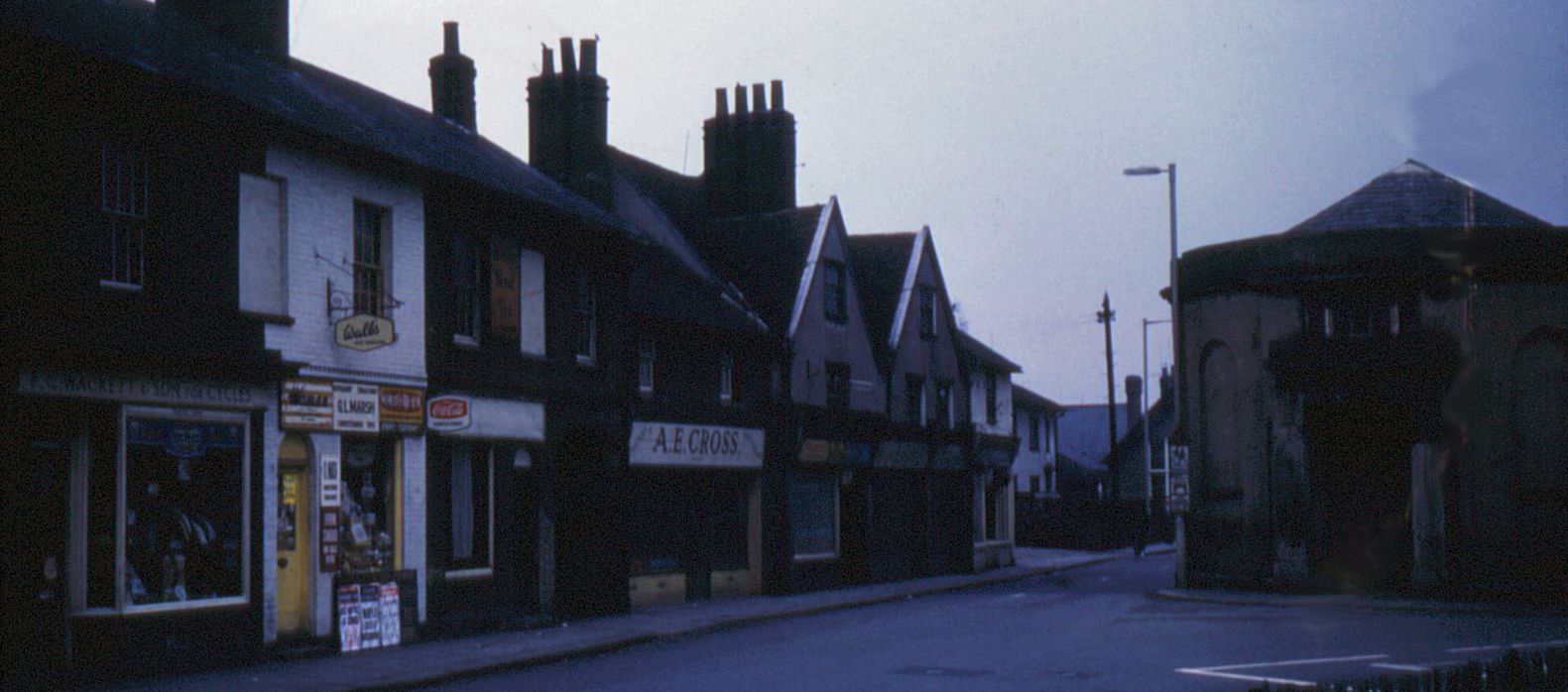
85 St Andrew Street; B. Bradley (Trustee for Mrs D. Rothery); 72 sq.m; 40
A.E. Cross operated the shop premises dealing in grocery & provisions and also occupied the living accommodation.
83/83a St Andrew Street; R. Hollman; 45 sq.m; 41
This provided an access-way at the side to 83 & 83a St Andrew Street.
81 St Andrew Street; G.W. Patmore; 61 sq.m; 42
This property was a dairy produce shop.
79 St Andrew Street; Mrs Emmett; 65 sq.m; 43
This building served as a newspapers & tobacconist shop run by Mrs Emmett.
77 St Andrew Street; R. Ginn & Sons; 75 sq.m; 44
This shop was a cycle shop long before cycling became popular Olympic sport. The emporium was run by F.C. Wackett & Sons; selling cycles and accessories.
73/75 St Andrew Street; R. Ginn & Sons; 155 sq.m; 45
These properties provided an access-way to builder’s yard which belonged to the building contractors (I assume R. Ginn & Sons). Officially, they were listed in the commercial directory as “decorators”. Also, it provided admittance to the builder’s offices.
71 St Andrew Street; F.J.Cull; 250 sq.m; 46
Office building serving the Ministry of Pensions & National Insurance. The government appointed agencies were relocated to Sovereign House close to bypass by Richard Hale School.
69 St Andrew Street; F.J.Cull; 147 sq.m; 47
The accommodation was occupied by Mrs B.L. Spicer
67 St Andrew Street; F.J.Cull; 321 sq.m; 48
J.W. Samuel; Confectioners & Tobacconist; B.J. Goldings (Pavitt’s Yard). Shop and living accommodation. This parcel includes part of Pavitt’s Yard.
65 I/J/K/L/M St Andrew Street; Hertford Borough Council; 310 sq.m; 54-8
These parcels of land (I/J/K/L/M) were the property of Herford Borough Council. They lay on the southern side of St Andrew Street to the east of Pavitts Yard.
63: St Andrew Street
Nothing is declared about the owners of the property or the type of shop it was.
61 St Andrew Street; The Red Lion (PH); Original owners McMullen & Sons
The Red Lion public house was an historic establishment in Hertford owned by the McMullen family. It had served ale to its customers for as long as people can remember but the premises finally put the towels over the pumps and was demolished in 1965.
59 St Andrew Street; Hertford Borough Council; 174 sq.m; 59
Although this is not listed as such, I assume this area was designated as 59 St Andrew Street. This section of land situated to the south-east direction of the previous property formed part of the back-water to the River Lea. Also, it was owned by Hertford Borough Council.
57 St Andrew Street; Hertford Borough Council; 2883 sq.m; 50
This parcel of land situated to the south of St Andrew Street consisted of office buildings, builder’s yard and ancillary buildings. It was owned by Hertford Borough Council. On this site was a stone-faced building to the left-hand side of the public house was known locally as “The Store House”.
55 St Andrew Street; Hertford Borough Council; 79 sq.m; 52
The Mary Pettyt charity is a long established aid organization dating back to 1641. The alms houses consisted of 4 terraced houses; numbers 55A, 55B, 55C & 55D St Andrew Street. They were built in 1826, in an effort by the Charity Commissioners to ‘tidy up’ some of the old charities in Hertford. The commissioners proposed to the new trustees with the power to sell the properties also known as the Mary Pettyt Alms Houses. (Source: Hertfordshire Mercury; 1 June 1967).
53 St Andrew Street; B.J.Frost; 48 sq.m; 51
The last casualty in St Andrew Street was the building that was the premises of B. J. Frost: a butcher by trade. The photograph shows that the butcher’s shop was next door a large symmetrical building known as ‘Cawthorne’; which is a Grade II listed building. Also, known as Merchant House, it was the last building at the end of St Andrew Street to avoid the wrecking ball and still stands today. Looming over both buildings is the church spire of St Andrew’s Church.
St Andrews Street: Even numbers
There was only one piece of land listed in the compulsory purchase schedule that was listed on the northern side of St Andrew Strret.
60 St Andrew Street; F.C. Sparkes; 44 sq.m; 37
This property formed part of an open yard adjoining adjacent buildings.
Water Meadow
~; The Trustees of the Salisbury Trust; 1889 sq.m; 60
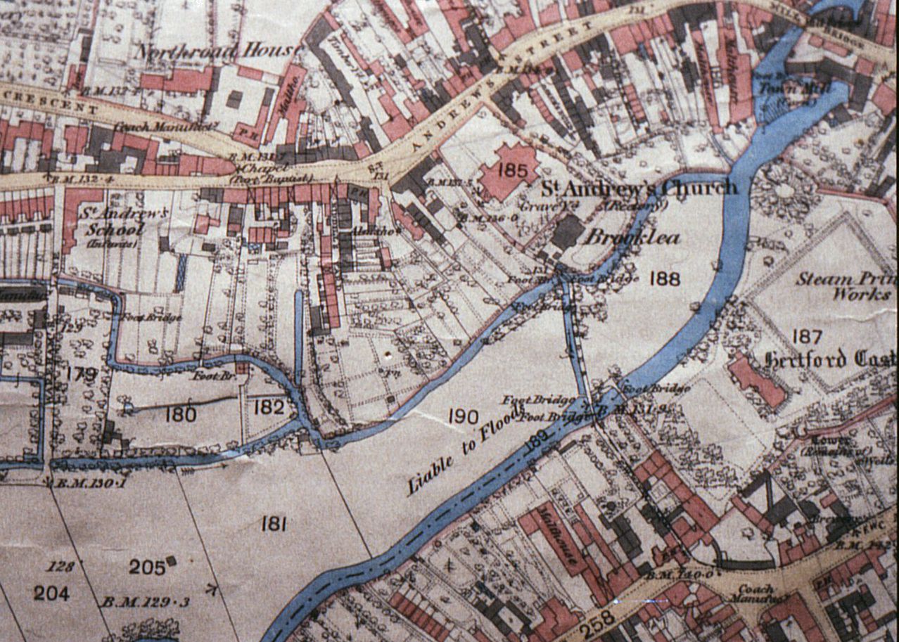
This large expanse of land known as The Water Meadow lay to the south-west of Hertford Castle. It also forms part of Ordinance Survey Plot No. 271, Herts Sheet XXXIX 15; 1923 Edition.It acts as the flood plain for the River Lea. It is the flat land that runs alongside a body of water, such as a stream or river, particularly around those that meander. In normal conditions, this land is dry. When water flows over the banks of a stream or river during times of flood, however, this land becomes flooded. An individual flood plain’s size is influenced by the size of the river, the volume of water carried by the river during a specific amount of time and how often the river floods.
Water Lane
2 – 12 (even numbers) Water Lane; Hertford Borough Council; 564 sq.m; 64A
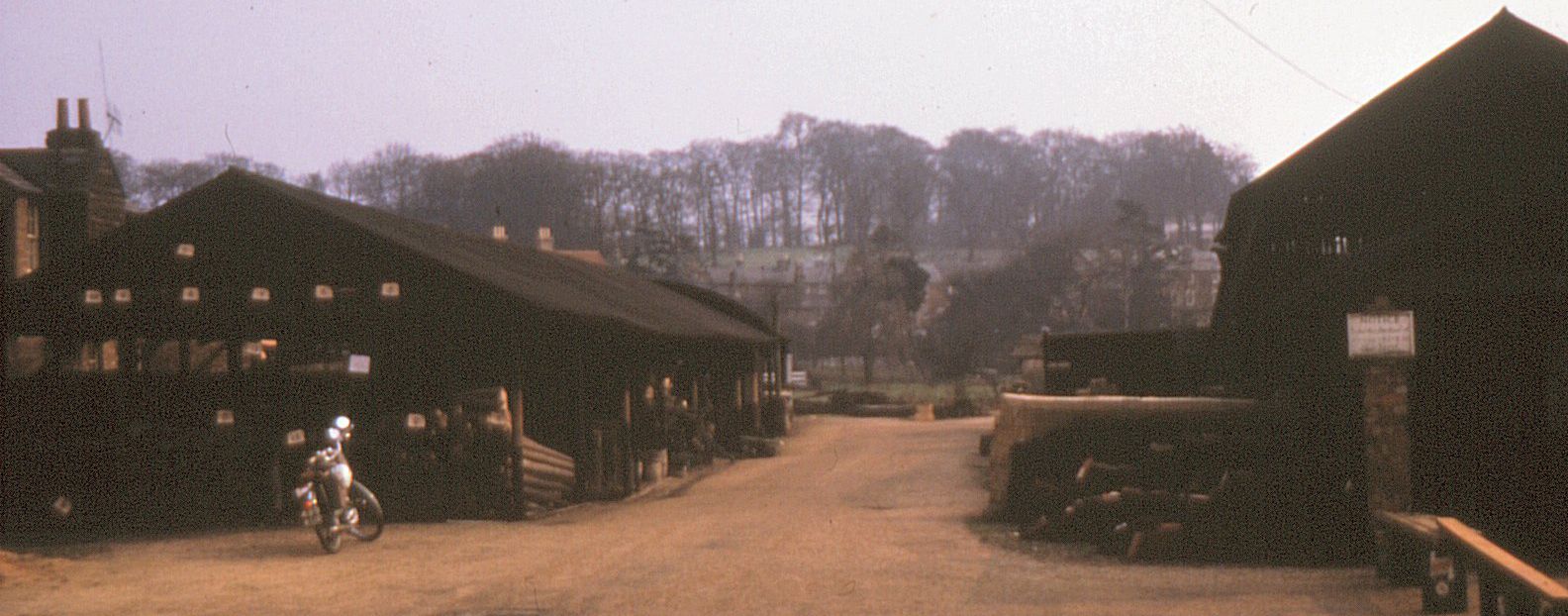
The plot of land known as Water Lane consisted of a larger plot of land that encompassed smaller parcels of land taken from these 6 properties that reside in the grounds of the Hertford Castle. Water Lane itself ran from the junction of Castle Street, West Street and Pegs Lane (by the Chaseside Motors Garage) down behind the cottages, past the brick wall alongside the playground situated in the grounds of Hertford Castle, over the bridge, alongside St Andrew’s Church and out into St Andrew Street. The only photograph of the Water Lane footpath was taken from the West Street end of Water Lane and is shown running close to the backs of the cottages. In the distance are the buildings situated in St Andrew Street itself. The aforementioned junction now resided in the middle of the dual carriageway that is part of the relief road
River Lea
~; B.Dodd; 48 sq.m; 60A
This is a section of land lying to the south-west of the back-water to the River Lea. It also forms part of Ordinance Survey Plot No. 271, Herts Sheet XXXIX 15; 1923 Edition. The source of the River Lea rises in the Chiltern Hills at Marsh Farm, Leagrave, Luton and flows downstream discharging into the River Thames at Bow Creek, near to the Olympic Stadium. The river had to be crossed by the Hertford Inner Relief Road as it flowed passed the Hertford Castle.
~; The Trustees of the Salisbury Trust; 389 sq.m; 61
This area is registered on the compulsory purchase schedule as “…the bed of the River Lea…”
West Street
~; Nicholl’s Brewery; 317 sq.m; 62
The final section of land lying to the south-west of the back-water to the River Lea. It also forms part of Ordinance Survey Plot No. 271, Herts Sheet XXXIX 15; 1923 Edition.
The buildings that constituted W.H. & G. Nicholls; West Street Brewery and house was situated on the north side of West Street just where it joined Castle Street. Nicholls was a well-known purveyor of beers, wines and spirits. It was a small locally sourced brewery based in Hertford, which was overshadowed (literally) by McMullens Bros Ltd. Due to the decline in demand for Nicholls beer the brewery became the subject of the compulsory purchase order by the County Council. Possession of the brewery and house took place on the 30 Jun 1965. Once the Gascoyne Way was completed, a number of dwellings were built on the site together with arched entrance to the rear of the property.
The smallest plot of land purchased was 60 St Andrew Street, (44 sq.m) from F.C. Sparkes.
The largest plot of land was owned by Hertford Borough Council (2883m2).
The total number plots in this second section of the Hertford Inner Relief Road was 24 with a total area of 7936 sq.m.
Many thanks to Peter Ruffles who gave permission to use his extensive collection of photographs of Hertford to illustrate this series of articles. Rumour has it that Peter Ruffles was the first person to travel along the new inner relief road …on his push bike.
Other sections of the Hertford Inner Relief Road will be described at a later date.


Add your comment about this page
No 81 St. Andrew St. G.W.Pateman Dairyman.
No 79 St. Andrew St. G.Marsh Newsagent etc
No 63 St. Andrew St. was derelict for many years,at one time it was ‘Dews’ Shoe Repairs.
The land and buildings, no’s, 70,70a and 70b St.Andrew St. were compulsory purchased for the by-pass. My father was the last tenant of no’s 70 and 70a, trading as Fred Roche, Shoe Repairs. Soon to move down the street to no 56.