


The Hertford Inner Relief Road has transformed the face of town forever. Hertford was once a rural idyllic rural town concerned only with its own heritage, the brewing of beer and transportation of material by water but halfway through the 20th century Hertford had to come to terms with the meteoric rise of the motor car that was clogging the county town.
A survey was taken in the late 1950s to examine the flow of traffic in and around the environs of the county town of Hertford. They discovered that traffic converged on the town centre from all directions. 50% of the traffic congestion in Hertford was caused by traffic ‘passing through’ Hertford and not going to the town centre. An inquiry opened in the early 1960s to examine the possibility of a solution to traffic flow problems that had existed in the town for many years. It made a number of recommendations, which were rubber stamped by the Ministry of Transport
…and so the Hertford Inner Relief Road was born.
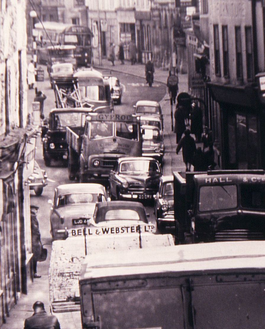
The route of the bypass set neighbour against neighbour. It was an unmitigating disaster if you had lived in Hertford all your life; whereas if you were one of the daily commuters it was a blessing in disguise. The dual carriageway was driven through the heart of the town from the Hertingfordbury Road railway bridge in the west, over the River Lea, passed Hertford Castle and All Saints Church, behind the premises along Fore Street to emerge at the roundabout in front of the Christ’s Hospital Girls School the east. It destroyed many of Hertford’s historic buildings, cut the town centre in half and altered the whole way of life of the residents.
Information in the previous sections has been gleaned from the archives at County Hall, Hertford. The Compulsory Purchase Order (CPO) schedule contains interesting information about the various parcels of land; giving names & addresses of plots, who owned them, who they were rented to, their size and status of the compulsory purchase process. In general, the correspondence between the local council and the lawyers for the interested parties is limited to the objection for the compulsory purchase order, the date of acquisition of the land by the county council and the price to be paid. As the shops, offices and buildings became available they were acquired or let for a short rental period. In some cases only the title deeds of the premises just needed to be ceded to the county council. It took between 12-15 months to acquire all the necessary land for the construction of the bypass.
Work started in earnest on the provision of the Hertford Inner Relief Road in the summer of 1965. It took over 2 years to construct the dual carriage way to bypass the town centre. It was finally opened in anger in the November 1967. As predicted, it resulted in a 60% reduction in trade in the shops in the centre of the town, which resulted in the closure of many businesses only for them to be set-up elsewhere.
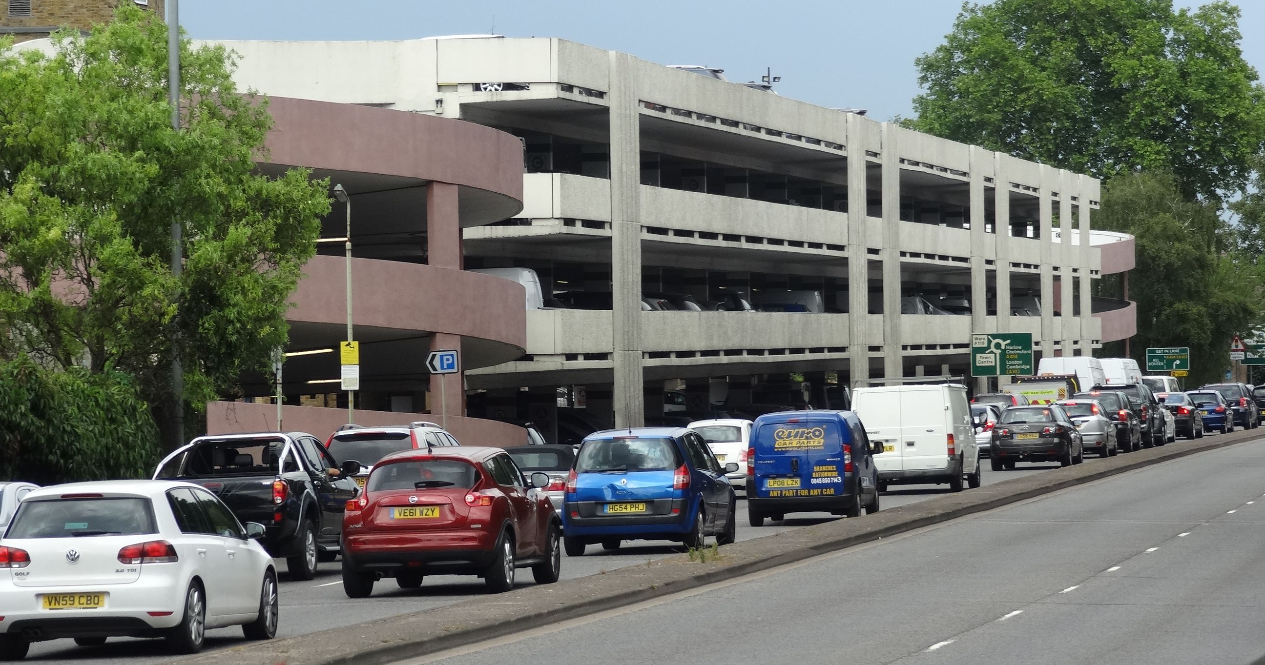
The situation has not been helped by the fact that the A414, of which the Hertford Inner Relief Road is a part, offers an outer alternative route for the orbital motorway system around London (M25). If there is a major incident on the northern sectors of the motorway then the traffic backs up using the A414 and once again traffic congestion returns to Hertford.
In the 1990’s, a proposal for a proper bypass around Hertford was planned to alleviate the traffic congestion once and for all. This was eventually rejected by the local authorities and residents on environmental grounds. Since the construction of the Hertford Inner Relief Road the levels of traffic have increased along the route, so much so that some motorists now use the town centre as a ‘rat-run’ to bypass the bypass. Various schemes to tackle this issue have been proposed but all have fallen by the wayside through injudicious financial planning, misappropriation of vehicle funding and the recent global recession. However, the long-term problems still remain to this day.
May I express my thanks to Peter Ruffles who gave permission to use his extensive collection of photographs of Hertford to illustrate this series of articles. Rumour has it that he was the first person to travel along the new Hertford Inner Relief Road …on his push-bike.
The Hertford Inner Relief Road is a bit like Marmite; either you love it or hate it. It has a distinctive taste which means there is no room for half-measures. It is a by-product of the beer brewing process, so it should have come as no secret to the local Hertfordshire brewers; McMullen & Sons Ltd who are based in Hertford. It was invented by accident at the turn of the 20th Century by a German scientist Justus von Liebig. It derives its name from the French for a large, covered earthen or metal cooking pot and used to promote the brand name. One of its claims to fame is that it is the perfect defence against mosquitoes.
So there you have it; you are either for it or against it; there is no room for sitting on the fence. One thing you can say is that the Hertford Inner Relief Road in its present form is with us for the foreseeable future.


Add your comment about this page
I’m not sure that ‘, misappropriation of vehicle funding’ is a statement that should have any place here and certainly could not stand up on court.
As as in incomer to Hertford, only been here for just over twenty years, this two part article has been a great read and incredibly interesting. The photographs have added an extra dimension to this town that I have come to love so much. Thanks.